Transportation and Driving Directions
Transportation to Santa Cruz
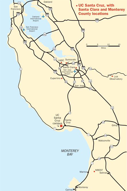
Santa Cruz is located at the top of the Monterey Bay on the Central California coast, just south of San Francisco. Getting here is easy since several major highways run to Santa Cruz, and the San Jose, San Francisco, Oakland, and Monterey International Airports are all nearby.
Airports
Santa Cruz is best served by San Jose International Airport (SJC), just 45 minutes away. Travelers may also use San Francisco International Airport (SFO), 2 hours away, Oakland International Airport (OAK), 2 hours away, or Monterey Regional Airport (MRY), 1.5 hours away.
Airport Shuttles
The Dickens Project does not provide shuttles from the airports to campus. You can find information about various transportation options by clicking on the airport links above. Below are links to airport shuttle companies that service the Santa Cruz area.
- ABC Airporter Service
(800) 840-0522
(831) 224-9391 - Early Bird Airport Shuttle
(831) 462-3933 - Paradise Transportation is a private door-to-door service; this is not a shared shuttle.
Call (831) 477-1200 for a reservation. - Santa Cruz Shuttles
(831) 421-9883
The Dickens Project organizes return shuttles to the San Jose and San Francisco airports on Saturday, July 27. The shuttles depart near College Nine and John R. Lewis Community Room. Please note on the shuttle registration form if you need assistance with your luggage.
- Shuttle to SJC ($55): The shuttle bus departs at 9:00 AM on Saturday, July 26, and takes about an hour to get to SJC. Reserve here.
- Shuttle to San Francisco International Airport, SFO ($80): The shuttles depart at 10:00 AM on Saturday, July 26, and take about two hours to get to SFO. Reserve here.
Driving Directions to Santa Cruz and UC Santa Cruz
- UCSC Campus Map with 2025 Registration Location (PDF)
- Driving Directions to Cowell Nine and John R. Lewis College Apartments Building 2 via Google Maps (link)
 UC Santa Cruz is located on California’s Monterey Bay – 75 miles south of San Francisco, 45 miles north of Monterey and Carmel, and just over the coastal mountains from Silicon Valley and the San Jose International Airport.
From Oakland: Take Interstate 880 South to San Jose, where the freeway becomes Highway 17. Continue on Highway 17 South to Santa Cruz. On the outskirts of Santa Cruz, take Highway 1 North (toward
From San Jose: Take Highway 17 South to Santa Cruz. On the outskirts of Santa Cruz, take Highway 1 North (toward
From San Francisco: Take Highway 101 South or Interstate 280 South to Highway 85 South. Take 880 South (which becomes Highway 17) to Santa Cruz. On the outskirts of Santa Cruz, take Highway 1 North (toward
From Walnut Creek/Concord: Take Interstate 680 South to San Jose, where it becomes Interstate 280 North. From 280 North, take Highway 17 South. On the outskirts of Santa Cruz, take Highway 1 North (toward
From Sacramento: Take Interstate 80 West to the exit for Interstate 680 towards San Jose. In San Jose, Interstate 680 becomes Interstate 280 North. From 280 North, take Highway 17 South. On the outskirts of Santa Cruz, take Highway 1 North (toward
From Los Angeles: Take Interstate 5 North. Take Highway 152 West, to Watsonville. Take Highway 1 North to Santa Cruz (toward Half Moon Bay). On Business Highway 1 (Mission Street), travel approximately one mile north to Bay Street in Santa Cruz. Turn right on Bay and proceed up the hill to the main campus entrance.
From Santa Barbara: Take Highway 101 North, then Highway 129 to Watsonville. On Business Highway 1 (Mission Street), travel approximately one mile north to Bay Street in Santa Cruz. Turn right on Bay and proceed up the hill to the main campus entrance.
Directions to College Nine and John R. Lewis College from the Main UCSC Entrance
Once you pass
Please note: if you are using Uber or Lyft, please direct your driver to 725 John R. Lewis College Road, Santa Cruz, CA 95064 or College Nine-John R. Lewis Apartment Building 2.

